The Oregon Badlands Wilderness is quickly becoming my "go to" spot for hiking and exploration. Access is less than 30 minutes from town, yet the crowds are nonexistent. My original plan for this day was to check out Tumalo Falls, but when I arrived vehicles lined the road leading to the trailhead and people poured from them with snowshoes and nordic skis. It was so crowded that I immediately turned around and headed for the Badlands. Solitude is a big part of why I like the outdoors, and nothing outside turns me off faster than crowds.
An hour later I'm in the Badlands. The hike was usual Badlands fare; flat terrain, Junipers aplenty and all the solitude a man could want. Unlike my first foray into this wilderness, Badlands Rock Trail occasionally opens up to views of the surrounding hills. The Junipers here are more sparse. The country just feels more open. I'm struck by the sheer number of birds I see and hear in this wilderness. I'm accompanied by birdsong everywhere I go.
From atop Badlands Rock
I was surprised by the size of Badlands Rock when it finally came into view near the 2.5 mile mark. I wasn't expecting it to be so big, and was overcome with the urge to climb it. The scramble was a bit tricky due to ice and snow, but the view from the top has to be the best in the entire Oregon Badlands.
Unnamed hiker on top of Badlands Rock
More views.
From Badlands Rock, one has two options for longer loop hikes. I went west on Castle Trail which had not been used since the most recent snowfall. Breaking trail was slow going. By the time I reached The Castle (halfway between Badlands Rock and The Flatiron) I felt like I was on a race against time to beat the setting sun, so I retraced my steps back to the trailhead and made it just in time. This area definitely deserves so more exploration. I like the idea of backpacking here, but being a relatively new wilderness, and playing second fiddle to the cascades, I have not seen nor heard of any backcountry campsites... Until next time.
After a night of beer swilling and cigar smoking around the campfire at Jumbo Rocks, Saturday dawned too soon for me. But I knew from past experience that nothing cures a hangover faster than a hard day's hiking. When we pulled the van into the 49 Palms Oasis trailhead, I knew this trip wouldn't be like the Maze. For starters there was a trailhead and a sign. There were also probably 20 vehicles parked there too. Today we would have company... Damn.
Descent into the Oasis
This area of the park is quite different than where we camped at Jumbo Rocks. There are no Joshua Trees here. In fact, it reminded me of Squaw Peak in Phoenix. A lot of of rocks and creosote, and not much else. The lack of shade would have been a problem if we weren't already intimately familiar with desert hiking. I imagine it could be a problem for park visitors from parts further north. After a 300 foot climb we were rewarded with views of the city of Twentynine Palms, and a teaser of the fan palm oasis that was our goal. The lush green palm grove in the middle of brown barren desert looked so out of place. In Arizona, where I live, palms aren't native to the desert, so outside of the city you just don't see them.
Checking out the palms with my binos.
Approaching the oasis.
When we reached the oasis we unintentionally crashed a midday Boy Scout party. There were 15 to 20 preteen boys and 5 adults. The boys were sprawled out on a huge boulder jabberjawing, while most of the adults were lazing about in the shade. Two of the adults were exploring the oasis past the signs that implored hikers not to travel any further because of the "sensitive ecological area." Apparently disregarding signage is a favorite pastime of some 49 Palms Oasis hikers as at least a half-dozen of the palms (that I saw) were covered with graffiti in the form of really bad carvings. Greg, Chad, Victor and I found a spot in the shade and talked about how cool the oasis was while snacking on beef jerky and gorp. For all of us, it was the first time seeing such an oasis, and I remarked to the guys how much fun it would be to overnight there. It was the only spot in three days at Joshua Tree that we saw water.
Hanging out at 49 Palms Oasis
Despite the traffic, 49 Palms Oasis was a cool little hike. I just wish it was about 5 miles longer to discourage the riffraff, and I don't mean the Boy Scouts. The park rates this hike as "moderately strenuous", but for us it felt like a literal walk in the park. By the time we returned to the van at the trailhead the day was half over, and we were thinking of a place we passed on the road through the park called Hall of Horrors. Who wouldn't be intrigued by a name like that? Stay tuned.
With archery deer season a month away I've been itching to get outside for some scouting. I returned to the spot in Tonto where I put a stalk on a large mule deer buck last season. There's so many places here that I want to explore, and Sugarloaf Mountain has been on the top of the list. This time of year the desert is so nice. The heat is a shadow of its summer self. This area is a favorite of mine, partly because of its location to my house, but also because Cave Creek provides a reliable source of water in the desert, which is a rarity. So, I was shocked when I reached the creek and found it bone dry. The usual clear flowing water replaced with a bed of sand and dry cracked mud. I've been here over 20 times in the last 3 years, and I've never seen it dry.
Coyote or lion?
The dry creek bed offered me a rare chance to experience the area's wildlife in a whole new way. I saw dozens of tracks dried in the mud as I abandoned the trail and walked north in the creek as it wound further into the mountains. I spotted plenty of bird and rodent tracks, but no deer. I also saw what I originally took to be lion tracks, I was sure they were lion as I followed them along the bed, but after I got home and studied the photos I now believe they belong to a large coyote.
Garter Snake
I slowed down as I reached the approach to Sugarloaf where I saw the buck last season. It's hard to be quiet in the desert, and my footfalls were crunchy on the loose rocks. I almost stepped on a snake that was crossing the ground in front of me. I love seeing any kind of wildlife in the desert, so even a common garter snake will cause me to pause and just watch for awhile. Climbing up a nearby mountain was slow going, The country here is rough and rocky, and full of all manner of cacti. My pace was slow as I navigated the terrain, while trying to stay quiet and watch for rattlesnakes. Finally I reached a good spot with views of the valleys and hillsides surrounding Sugarloaf. I sat on my pack and glassed the day away with my new binoculars. I picked up a set of 10x42 Alpen Wings to replace my old Bushnells. They looked great in the store, but out in the field they just don't seem to be as good as I hoped.
It was a fun and productive day. I didn't spot any deer or see any sign other than a few old tracks. Certainly, I didn't see anything to make me believe that deer of any number are in the area. I didn't even find any scat. Before I cross the area off my list as a potential hunting location I think I need to spend the night out there so I can glass at dusk and dawn. Such a trip is at least a week away however, as I am heading to Joshua Tree for three days on Friday. Stay tuned.
So, I finally got around to making a video about my backpacking kit. It was a lot of fun making, and I'll definitely be making more in the future. It did turn out really long though, which isn't too surprising considering I can be very long winded when talking about something I'm really passionate about like backpacking. This is worth a look if you are interested in desert gear or just lightweight/minimalist gear.
Some of you may know that I took up the bow recently. I can't believe how much fun it is. I can't believe it took me 36 years to pick one up. Archery deer season began in January, and with it a new reason to get outside. Some people evolve from backpacking to climbing or mountaineering, but for me, I'm evolving toward self-reliance. That's what I've always loved about backpacking: relying on myself for everything. That's why I chose a recurve. It's simple. It takes skill and instinct developed though practice. Hunting, I think, is the next evolution in that self-reliance concept that I'm pursuing.
Jim and I decided on the Cave Creek area of Tonto National Forest for our hunt. We both know that area very well, and that played a big role in our decision. That area isn't exactly known for an abundance of mule deer, but a trail cam nearby at Spur Cross Ranch Conservation Area convinced me that it would bear fruit. I follow Spur Cross Ranch on Facebook and they post regular photos from that cam on their Facebook feed. Besides coyote, bobcat, javelina and mountain lion, I have seen plenty of deer on that cam, including at least one large buck. We hunted the area just north of the conservation area.
Camp for the first 2 days.
It was exhilarating hiking under a full moon late Tuesday night. It was my first time backpacking that I've started at 9pm at night. The desert was alive with night sounds and the many creek crossings kept us on our toes. About 4 miles in we camped high on a saddle near Skull Mesa. The wind was roaring and I was concerned that my tarp would take a beating. I set it up in a simple windshield type configuration with the windward side nearest the ground. I didn't get much sleep with the wind pounding my tarp all night. I kept expecting it to collapse, but it didn't.
It was dark when we awoke. After a quick cup of coffee we geared up and hit a hillside that we expected would be a good position for glassing. We had great views into a large valley that the creek ran directly through. To me it looked like a perfect spot for animal activity, but we didn't see anything all morning. There was an even higher peak just to the south of us, so we decided to climb that to gain a different vantage point. Near the top we saw javelina sign everywhere. Holes in the ground. Half eaten prickly pear. Dug out beds under paloverde trees... And just like that javelina were darting about all around us. We saw big ones, small ones, and even babies. We walked right into a javelina herd that had bedded down for the day. Most of them just scattered, but one particularly large javelina stood 10 yards away from me staring at me. I clutched my bow waiting for him to charge me, but he didn't. Frankly I'm not sure he could even see me very well. I told James that if we had javelina tags we would have filled them the first day of the hunt.
Rusted out old Ford.
Our new vantage point on the mountain-top didn't reveal anything new. The valley appeared void of any animal life. We glassed until around 1pm, and not seeing any sign, we hiked down to the valley to get a closer look. Down at the bottom we saw some really cool Hohokam petroglyphs. Although I've seen them before, I always have to stop to check them out when I'm nearby. It still amazes me what the ancient people of the desert were able to accomplish in this dry, harsh landscape. We spent the rest of the day scouting the valley we had glassed all morning. We saw javelina and coyote sign everywhere. We saw bobcat tracks, and a rusted out old Ford that someone had dropped very purposefully over a drainage to presumably act as a bridge. But we didn't find any deer sign at all. We needed a new plan.
Jimbo glassing
That night I saw my first ever wild scorpion. It crawled out from underneath a rock when I was preparing to start a fire. It only took 2 and 1/2 years of desert dwelling to see one! The wind on that second night was even more viscous than the night before. But despite the 40 mph gusts I slept much better. I think because I wasn't worried nearly as much about the stability of my tarp. I just knew it would hold, and it did.
The next morning we moved to a spot that Jimbo had picked out from the map. It was closer to the conservation area, and we reasoned that maybe the deer were staying closer to the park because they just instinctively knew it was hunting season, and of course hunting is illegal in the park. Hiking up a hillside Jim spotted a large buck not 30 yards in front of him. He said later that it was the largest buck he'd ever seen in Arizona (and he grew up here). The buck was onto us immediately and literally the second Jim stopped and whispered "buck", it dropped into a wash and out of sight. We came up with a plan of action right away. I would flank high up the hill and try to drive the buck down the wash into Jim's position below. I nocked an arrow and crept up the hill as quietly as I could. It's hard sneaking in the desert with all the pokey plants everywhere. I was stuck by multiple cacti during my maneuver. I reached the top of the wash and spotted Jim below. We both looked at each other and raised our arms as if to say "where did he go?" We spent the rest of the day trying to track that buck to no avail, but the good news was that new spot we were in was full of deer sign. We decided to move our camp lower so we wouldn't have to make the hard hike up and down the mountain the next day,
Our new camp was near the creek and the wind was nill. Some critter made a racket in a wood pile nearby, and the entire area was covered in Javelina tracks. A spider the size of a mouse scurried through the sand near my tarp, and I was briefly concerned that I would be sharing my sleeping bag with it or one of its friends. We enjoyed the peaceful night as we sat by the fire and planned out the next day. Even though we had come up empty so far, we felt good about our prospects for the next day in this new spot.
It's me.
Early the next morning we were glassing from a hill at the same location we spotted the buck the day before. We spent all morning out there searching in vain. The desert mule deer is not easy to find, and we reckoned that the deer were even closer to the park then we originally thought. All in all, our hunting trip turned into a 4 day scout, as we only spent one day doing any real hunting. We simply could not find the deer. But it wasn't time wasted. I learned a ton... The desert is an excellent teacher.
Backpacking during the holidays is great because everyone is at home. My Uncle Steve and I used to backpack every 4th of July. We relished the solitude and chance to have the wilderness to ourselves. So it was in the Superstitions last week. Although the Peralta Trailhead was jampacked with vehicles, we encountered only one other group of backpackers in an area that is usually extremely popular.
Rocco lapping up water
The trick with the desert, and indeed the Superstitions, is the lack of water. Due to the recent rains however there was plenty along the trail. It was great for Rocco who had lots to drink and plenty of chances to cool off. Water also gives the backpacker peace of mind. Up in the Pacific Northwest I always took water for granted. Down here in the desert it's a luxury. To have available water is a big confidence booster when backpacking in the desert.
The Superstitions
Our original plan was to connect several trails to make a clockwise loop from Peralta Trailhead and overnight at LaBarge Spring. We arrived at the trailhead much later than expected however and had to change the plan. After a relatively easy jaunt through thick desert scrub we arrived at Terrapin Pass near the base of the famous Weaver Needle. The pass offered amazing views of the desert mountains so we decided to make camp. The only drawback was that there was very limited space for pitching tents and no cover from the wind. So, I pitched the tent (for the girls) and my tarp nearly right on top of each other on the only relatively flat spot in the area.
Terrapin Pass camp. Weaver Needle in the background.
Lying under my tarp with Rocco that night I felt him shivering like crazy. I felt bad for him so I unzipped my sleeping bag and let him crawl in as much as he could. It didn't work. He was still shivering. I couldn't figure out why he was so cold because his body felt warm and was radiating tons of heat. Eventually he crawled into the tent with Sarah and Bianca. I'm sure it was cramped quarters in the tiny 2-man tent, but it was the only thing we could do to keep the dog warm. At about 3am the wind picked up intensity. I had to get out and tighten the guylines to prevent the tarp from flapping so much, The wind was blowing really hard up on that pass. I'm guessing 40 mph or more. When I awoke around 6am, I saw that my tarp had partially collapsed. I also saw that the wind was hitting the tent at a direct broadside, which bowed it nearly in half. Normally when I anticipate heavy wind like that I would pitch the tent with the most aerodynamic end facing into the wind. but the area we were camping prevented me from doing that this time.
Sarah, Bianca and Rocco on Terrapin Pass.
Despite a freezing dog, a partially collapsed tarp, and a beat-up tent, we still had a great time. The temps were perfect and the scenery was amazing. If you've been wanting to get into the Superstitions, this is a perfect time. The recent rains have filled the springs and sprinkled the lowlands with pools of water. If I can find the time, I will return as soon as I can.
I awoke on day 3 feeling refreshed. The tranquil sound of slow running water lulled me into a deep sleep that was a welcome change from the blasting sand from the night before. After a quick breakfast we backtracked up the drainage. The day before on the way down I wondered how we would get out of there. Sliding down rock was one thing, but climbing back up seemed an entirely different animal. My worry was for nothing though, because the climb out was easier than expected. By day 3 all of us were so used to scrambling that it had become just like walking. You just did it without thinking. The path of least resistance came naturally.
Climbing out of the drainage. Photo by Mike Scussel
After the last obstacle we reached a large plateau surrounded by gigantic cliffs. The views were spectacular. For the first time since early day one, we were on an actual trail, and made good time. Not that I necessarily wanted to hurry. The views were so amazing that I would have been content camping right there, it was that beautiful. When I hike or backpack, I usually take my time to just soak in the wonder of it all... But we had a 10 mile day, including a twenty-foot rappel. We had to move.
The plateau on day 3. Photo by Mike Scussel.
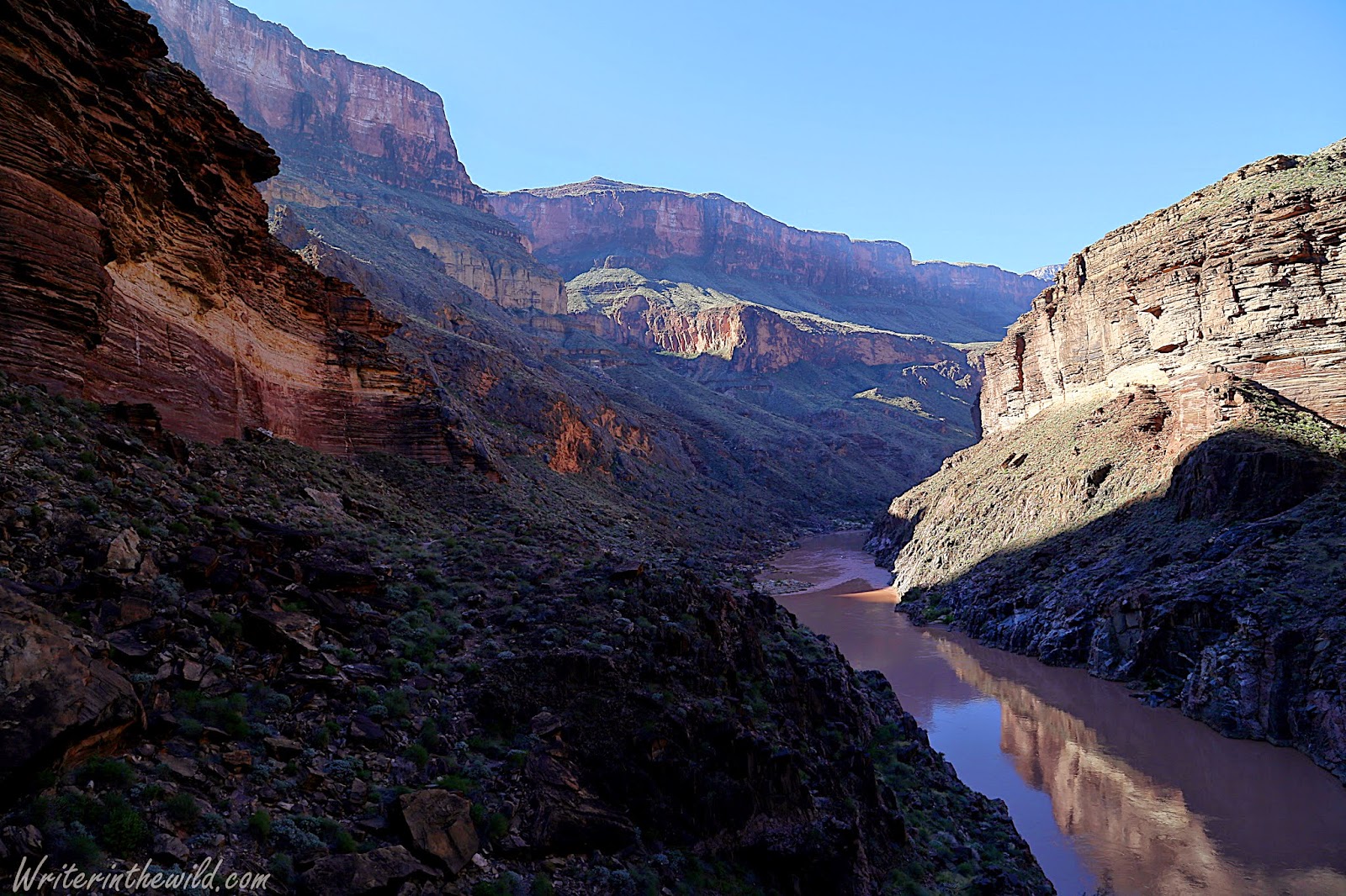
We got out first excited glimpse of the Colorado River far below. I kept thinking that it looked like a chocolate river out of Willy Wonka it was so brown. As the miles ticked by the terrain got steeper. The trail paralleled the edge of the canyon, and we were forced to walk precariously close to it most of the day. Sometimes the trail would put us right on the edge. I'm not afraid of heights, but we were so high and so exposed that I couldn't help but feel that rumble in my guts every time I peeked over the edge.
Hiking exposed on day 3. Photo by Bob Cagle
Our destination that day was Toltec Beach. The problem was that the trail didn't actually go to Toltec Beach due to a cliff in the way. The only way to reach it is by a twenty foot rappel. For me, this rappel caused more pre-hike apprehension than even the Ledge of Death. Mainly due to the fact that I had never repelled in my life, and I would have to rely on someone else for the equipment and expertise. The sight of the rappel was a narrow ledge that jutted maybe 5 feet out from the cliff-wall. We all removed our packs and sat with our backs against the cliff while Mike rigged the rope. My original plan at this moment was to volunteer to go first so I could get it over with, but Bob beat me to it. From our position on the cliff we were closer than ever to the river, and watched rafters float by as we waited. Out of the group of 5, 3 of us had never rappelled, and I think it's fair to say that we were all nervous... But it was a good kind of nervousness. An excited nervousness. Finally the rope was rigged and Bob took the plunge. We watched tensely as he leaned all his weight on the rope and harness and backed down the cliff. After he reached the bottom Mike looked over at me with a big smile on his face and goes, "Yes! That was my first time ever setting up a rappel by myself." I looked at him and said, "Dude, couldn't you have waited until I was at the bottom before you told me that?" It was all in jest because by then Mike had definitely earned my trust. Besides, seeing Bob make it to the bottom helped to settle me some. After a crash course in Rappelling 101, it was my turn. I think the hardest part for me was just trusting the equipment. Once I realized that the gear would support my weight the descent was easy. The entire time down I kept thinking about how much fun rappelling was, and when It was over I wished that it wasn't.
Video Below: My first ever rappel.
After we made it down safely, it was just a short jaunt to the beach where we would make camp. At the beach we ran into a couple hikers. It was the first people we had seen in 3 days. As much as we all wanted to make camp and relax, our day wasn't yet done. We still had a 3 mile round-trip to make if we wanted to see Elves Chasm. The hike to Elves Chasm was actually the toughest we'd done all day, and when we arrived I was totally pooped. Elves Chasm is a beautiful little waterfall and swimming hole carved right out of the sandstone. I took my shoes off and just let my sore feet soak in the cool water.
Mike and I at Elves Chasm. Photo by Bob Cagle
Back at the beach we sat around laughing and joking about the day we had. I think all of us felt a real sense of accomplishment even though we still had 2 days to go. I fell asleep knowing that from then on the route would be all uphill. Working full-time, going to school full-time and still making time for family didn't leave me a lot of time to train. I knew from the start that climbing out of the canyon would be my greatest challenge.
Leaving the river behind. Photo by Bob Cagle.
Leaving The Colorado River behind was bittersweet. It took so much hard work to get there that it felt like we should stay longer. But we had a schedule to keep. Before we left we topped off on water. Our destination at Copper Canyon was ten miles away, and there would be no water sources in between. We weren't even sure if we would find water at all once we got there. The day's hike was a moderate climb packed full of views. It was our first day without any scrambling, and it gave me time to enjoy the never-ending views and contemplate the amazing landscape I was in. I kept thinking that it was no wonder I had never seen any Discovery Channel survival show on location in The Grand Canyon. It's just too extreme. Looking around I wondered what it would take to survive there: treacherous terrain, scant shade, little water (except at the river), and barely any game or wild edibles. I couldn't help but feel respect and admiration for the native peoples that lived down there and even the first whites to explore it. The Grand Canyon is without question the most hostile place I've ever been.
Having fun at Copper Canyon camp. Photo by Bob Cagle.
We reached a bone-dry Copper Canyon late in the afternoon. We were nearly out of water, and the water we were hoping to find did not exist. We fanned out to search the 3 or 4 small drainages that fed Copper Canyon hoping to find something drinkable. Thankfully Mike found 2 large puddles about a half-mile up from our camp in one of the drainages. The day before, Mike's MSR Miniworks water filter completely failed, and David's Steripen was working only intermittently. Chris hadn't brought a filter and was completely relying on us for drinking water. Luckily I had a Sawyer Mini and Bob had a Sawyer Squeeze. What I love about Sawyer filters is the simplicity. There are no moving parts or complicated electronics. There is nothing to fail.
Chris and I. Photo by Mike Scussel.
The hike out was a bitch, at least for me. My stomach still bothered me from the day before. The terrain was steep, and it seemed like no matter how much progress I made I wasn't getting any closer to the top. The day was a blur as I spent most of it just watching my feet, too tired to pay attention to any views. About 3/4 of the way to the top I had just a couple ounces of water left and was on the verge of upchucking. Chris ran ahead (despite his bum knee) and alerted Bob (who had already finished) who brought me down some more water. After a good 20 minute rest, I powered on out. I was glad the climb was over.
Climbing out. Photo by Bob Cagle.
The Grand Canyon is an extreme place. I know I've mentioned that before in this trip report, but it's so true. It's something you can't quite understand until you've been there. If you ever get a chance to go, do it. Just make sure you're prepared. Any mistake in the canyon can quickly lead to disaster, especially if you aren't on the more popular corridor trails. Overall our trip was awesome. Everyone had blast even though it took us some time to recuperate. Thanks for reading.
"Death is a real possibility on this trip." - Mike Scussel (trip leader)
"...this hike offers about a million ways to get into serious trouble in a remote part of the Grand Canyon." - National Park Service
Descent into the Grand Canyon. Photo By Bob Cagle
Other than from the window of a passenger plane, I had never seen The Grand Canyon before. I didn't comprehend its scope or power. I didn't understand what I was getting myself into when I agreed to go. Even though The Royal Arch Loop was listed as "extremely difficult" in a canyoneering book I'd read, and even though The National Park's Grand Canyon website recommended experienced grand canyoneers only, I still didn't quite get it. For me, trips always seem to come down to one thing: Can I deal with whatever nature throws my way? Can I endure?
After a chilly night on the South Rim illegally camped next to a horse corral, we made the bumpy drive through Indian land to the South Bass Trailhead. We drove alone through the rugged high-desert country that marks this area, encountering only the bedraggled Havasupai who charged us $25 to pass through the reservation. A fee we would have swallowed easier if the rut-filled boulder-strewn road had been a little better maintained. At the trailhead we met a group coming out; two guides and a contingent of European tourists. Water was scarce they said. The five of us had brought enough containers to carry 2 gallons of water each, and the guides had plenty of water leftover after their climb out, so we topped off. It was a good thing we did.
My first thought after looking into the immense canyon from the south rim was one of skepticism. "I am going in there?" I asked my self incredulously. As infinite as it appears from the top, you really don't get a true sense of the scope until you are inside. It could have been the surface of Mars it felt so foreign; An endless maze of cliffs, and rock - and more rock. The descent was deceptively easy, because eventually I knew I would have to return the way I came.
Our fearless leader Mike Scussel
When we reached the esplanade my spirits were high; We were cruising, and the scenery was amazing, but as we dropped into the Royal Arch drainage the terrain changed. The trail was steep, and the soil loose underfoot. The way became difficult to discern, and route finding took more time. I slipped and fell, and when I reached out to stop myself from sliding down the embankment a sharp stone pierced the palm of my hand. It was the first of many small cuts and scratches I would get during the trip.
Getting Deeper. Photo by Bob Cagle.
We reached our campsite on a ledge near the mouth of the Royal Arch Drainage just before dark. Other than a small puddle, there was no water to be found. Our trip leader Mike decided to follow the drainage down in an attempt to find some water we had spotted from higher-up earlier in the day. We were all running low. He came limping back and cussing like a sailor. He had stepped in an agave, and the knife-like leaf had pierced about an inch-or-so into his calf. It wasn't a straight-in shot, but it looked painful. He treated it the best he could, and hoped aloud that it wouldn't get infected. In the meantime, I treated water from the small hole near our campsite. It contained about 2 gallons, but was so shallow it was difficult to extract.
First night's camp. Photo by Bob Cagle
That night the stars were incredible. We all noted how quiet the canyon was. It was something we all commented on during the course of the 5-day trip... The silence. In fact, The Grand Canyon is the quietest place I've ever been to in my life. At least in the area we were, which is much more remote and less traveled than the corridor trails in the more popular areas of the park. Here there were no mules, no tourists, no helicopters... Just nature.
I thought for-sure I would sleep well that night after such a hard day, but the wind picked up just before midnight and ruined my plans. Blowing sand and dust blasted me in the face. It didn't matter which way I turned. The sand covered my sleeping bag, and even got into my eyes and mouth. Finally I cinched my hood up so tight that I just left a small hole to breath from. It worked well enough that I finally fell asleep.
First night's water.
The next morning we cleaned as much sand off our gear and our bodies as we could. Not only did I wake up with grits in my mouth, but it was inside my sleeping bag and every other crack and crevice imaginable. Mike's leg was still hurting him, but he decided to soldier on. I felt bad that he was in pain, but I also did not want to turn around. It was only the second day! We were all eager to see the famed Royal Arch, but to do so meant a hard day of scrambling and climbing down the drainage.
A half-a-mile down we found the water we spied the day before: 3 large potholes filled to the brim with crystal-clear water. The discovery was just in time, as I had maybe half-a-liter remaining. Our progress was slow going. We squirmed and wiggled and slid down car-sized boulders on our butts. I think every one of us ripped a hole in the ass of our pants during the course of the day, but we didn't really care. We were having a blast.
Descending through the Royal Arch drainage. Photo by Bob Cagle
We eventually reached a huge dry-fall, which looked somewhere in the neighborhood of one-hundred feet, that dropped into a giant gorge with sheer cliffs on both sides. We knew we were nearing the infamous ledge of death, but Mike couldn't remember the route (it had been a few years since he had done this hike). Bob eventually spotted a faint trail leading up the cliff-wall to the right, and we all followed, except Mike who was still vigorously contemplating which route to take. My heart was beating like a machinegun as I climbed. Any slip would have meant certain death. At one safe point I turned around to check Mike's progress, but I couldn't find him. I began calling out his name. When he finally yelled back I spotted him across the gorge traversing a narrow ledge on a near vertical cliff. He had spotted the correct route, which was along the left wall, but the rest of us were too committed to turn back.
Video below: After reaching the dry-fall, Mike is deciding which way to go. The rest of us began traversing the cliff on the right, while Mike eventually took the cliff on the left:
Watching Mike traverse that ledge from across the gorge was the scariest moment of my hike. One mistake and he would have fallen to his death. Not that our situation on the right was any different, but being in a group gave me at least some sense of a safety net. With baited breath we watched Mike traverse the ledge. He eventually reached The Ledge of Death, which is a spot on the ledge where a fallen boulder has completely blocked the route. In order to pass it, Mike had to hold on the top of the boulder and squirm around the outside leaving his body literally hanging over the abyss. It was a tense moment for us four watching from across the canyon. The cliff was so huge, and Mike looked like an ant from our vantage point. But to our relief he made it, and when he reached a safe spot, he then watched our descent on the other side.
Looking across the gorge just after the Ledge of Death. You can see Mike standing on the ledge in the center of the pic. Photo by Bob Cagle.
We had to descend because the route across became impassable. Mike shouted over to us the route down that appeared the safest. We took our packs off, and with Bob leading the way, down-climbed between cracks in the cliff and over ledges and boulders, passing our packs down as we progressed. It was nerve wrecking because one slip-up would have been catastrophic. When we finally reached the slope at the base of the cliff, I was relieved but exhilarated by what we had just accomplished.
We descended to the slope from the top using the cracks in the cliff wall. I've dubbed this section "The Ledge of Doom". Photo by Bob Cagle.
David prepares for the last obstacle before the slope below the ledge of doom.
Our reunion with Mike back in the drainage was all smiles. We had conquered the most dangerous section of the hike, and we were all alive. The day wasn't yet done however, and soon we were back to sliding and scrambling. There were still plenty of dangers to go around. The largest hazard was falling, as it seemed like we encountered one obstacle after the next. But we got good at it, and worked as a team to negotiate the most difficult sections. By the time we reached Royal Arch we had hiked all day long, but covered less than 5 miles.
Royal Arch. Photo by Bob Cagle.
Royal Arch is the largest natural bridge in Grand Canyon National Park and it is spectacular. Just as incredible is a huge rock pillar that stands just past the bridge that looked like a wizard's tower from Lord of the Rings. The arch is an oasis in the desert, as water flows freely, and pools are deep enough to swim in. It was a welcome sight after the day we had. A couple of the guys jumped in the icy water for a bath, but for me it was time to just relax and contemplate what we had accomplished in just 2 days. By that second night, this trip was already the most difficult hike I'd ever done, certainly in terms of the danger involved, but also because the amount of off-trail travel. The route finding was constant. Every new obstacle made us pause to consider the best way forward, Sometimes there were rock cairns, left by hikers before us, but mostly it was a matter of taking a few minutes to look. I had not experienced a day like that before.
Tower near Royal Arch. Photo by Bob Cagle.
Billions of stars dotted the night sky. More stars than I'd ever seen since moving to Arizona. I was glad that I wasn't in a tent. Part of sleeping outside is just being outside, and we cheat ourselves out of that experience sometimes by sleeping in tents when we don't have to. Although all the climbing and boulder-hoping was engaging, I was looking forward to putting in miles on an actual trail. We still had 3 more days in the canyon, and I was already having the time of my life.
Fishing in the desert has been somewhat of a challenge for me. In fact, I've been skunked in every desert locale I've been too. I used to believe I was a semi-decent angler. Now I'm not so sure. So I was excited when I got an invite to fish a secret spot on the Verde River that always produces for a couple of Cave Creek locals I know. It was a beautiful sunny day, and despite the huge rains we had last week, the water was very low. The Honey Hole is a tributary of the Verde River that becomes landlocked when the water is low, trapping an untold number of fish inside. My friend Mike said the water at the Honey Hole was the lowest he'd ever seen, and I for one was dubious of fish even being in there because the water was just so shallow. Because of that mistaken belief, Jim and I started fishing on the river itself, with no success. Eventually we moved on to the Honey Hole after Mike started hollering about the fish he was catching. "I got one!", and "I got another one!" he would shout.
Jim at the Honey Hole
The water at The Honey Hole was shallow, stagnate, and covered in a purple algae that made fishing difficult. Mike caught 2 bass and a bluegill in an hour, so we knew there were fish in there, but when Jim and I arrived all was quiet. We fished The Honey Hole for maybe 2 or 3 hours without even getting a bite. Finally Jim trekked back to the river, and after after a few more minutes I followed. Literally 5 minutes after I left the Honey Hole, I hear Mike shout, "I got one!" I couldn't believe it. Back at the river nothing was biting, while Mike continued hootin' and hollerin' about all the fish he was catching.
The Honey Hole king
Reluctantly Jim and I trudged back to The Honey Hole to try and catch something before dark. We had been fishing all day with zero luck and our morale was in the toilet, especially with Mike catching so much. In fact Mike caught 11 fish in all. A smattering of bass and bluegill. Jim landed one large-mouth right at the end of the day, and I was skunked yet again. Damn. One of these days I swear I will post a fishing report where I actually catch something! It was still a great day of fishing though. Just being out there in the breeze listening to the buzzing bees and chirping birds made it all worth it.
As the hiking season winds down in higher elevations, in the Sonoran Desert it's just beginning. I've managed to spend a significant amount of time wandering the desert in the last month or so, mainly in The Phoenix Mountain Preserve, but a little in South Mountain as well, and I thought I would just share some observations, and some of what I've learned.
Hiking in 100 degree heat with the sun beating beating down on you is hard, and the first thing I noticed early on was that everything you do in that heat is harder than normal. You have to be prepared for those extreme conditions, because something as routine as a steep climb can leave you feeling sick and spent.
1) Acclimatize - The more you hike in the desert, the better you handle the heat. My first couple desert hikes left me feeling sick and slightly demoralized. If you plan on backpacking in the desert, I would recommend plenty of desert day hiking beforehand. Start small.
2) Temper Your Ambitions - Like I mentioned above, everything is harder in the heat. Expect routine distances and climbs to push your limits. What you can easily accomplish physically in milder climates will be a challenge in the desert.
3) Bring More Water - Unless you've hiked in the desert in summer, it may be hard to imagine just how much you can sweat, and how thirsty you constantly feel. In the last month, routinely hiking in 100 degree heat, I've found that bringing double the water I normally bring is just enough. Last Saturday I finished 4 liters on a 7 mile hike. Trust me, you'll need to drink much more water than normal. Also keep in mind that water is really going to dictate where and how far you hike. If you bring 4 liters and notice that you've finished 2 already, then its time to turn around and head back to the car.
4) Seek Shade - Heat stroke is a serious risk, and keeping your body from overheating is going to take effort on your part. If you come across shade, take your pack off and sit in it for a few minutes. Drink some water. Let your heart slow down. Let your body cool a little bit. I usually plan my breaks around shade instead of distances. I'll say to myself, "The next shade I come to, I'll take a short break". Trust me, it really helps taking a break in shade, versus taking a break in the sun, which can be totally miserable.
5) Bring Sun Protection - This one seems like a no-brainer. Keep sun screen in your pack. Wear a hat to keep the sun off your face. Wear a wide brimmed hat or drape a bandanna from the back of your hat to protect your neck. Wear polarized sunglasses. I have forgotten sun screen multiple times, and got burned for my stupidity. Now I keep a tube in my day pack at all times.
6) Keep Track of the Forecast -. I like to use 100 degrees as a good mark of when to start and when to stop. If it's 100 in the morning when I plan to start then I stay home, because it will only get hotter. If it's 100 in late afternoon when I plan to start, then I'll go, because it will only get cooler. Hiking in 110-120 degree weather is dangerous, and I wouldn't recommend it to anyone, but 100 is doable as long as its the peak temperature. You can beat the hottest times of the day by hiking near dusk and dawn.
So, those are just a few of the things I've learned in the last month. I'm not suggesting anybody run out to the desert and brave the heat, I'm just pointing out a few things I figured out, that really helped me. Desert hiking is a lot more doable in the winter months when the heat lingers in the 80's and water can be found in places dry during summer. I guess the smart thing to do is just wait for winter to hike in the desert, but living in Phoenix I basically have 3 options. Option 1: Don't hike. Option 2: Drive at least 2 hours north to escape the desert. Option 3: Hike in the desert. I have to take option 3 because I hike multiple times a week, and I cant make a 2 or 3 hour drive every time I want to hike. But hiking in the desert is doable. Just be smart and bring lots of water.
I didn't get out once last week. No backpacking or camping. No fishing or day hiking. It was a slow week in the world of outdoor adventuring. Its funny but now when I have those slow weeks, I feel guilty, like I'm not doing enough. I tell myself, "Its just a week", but it doesn't work. I cant shake the feeling that I'm cheating myself. So for today's blog a mix of flowers seen on the trail in the last month or so. Enjoy.